
A few weekends ago, Open House New York led a boat tour up the East River, offering a chance to witness the rapidly evolving coastline. The East River has played a prominent role throughout the history of New York. From the Dutch settlement’s earliest days, New York’s harbor has been integral to trade and the city’s economic vitality.
Since the end of the East River port’s dominance in the middle of the last century, the waterfront has seen many schemes for its future come and go unrealized. Such grand, unfinished plans included a new home for the New York Stock Exchange, and the first site pitched for the World Trade Center.
Now, in the midst of a golden age of development and prosperity, the creation of a re-purposed, post-industrial waterfront has actually begun. Piers are transforming into parks, and real estate transactions have become the new economic activity on the waterfront.
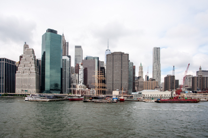
The tour starts in Lower Manhattan, where landfill has increased the size of Manhattan along the East River four times over the course of its 400-year history. Originally defined by Pearl Street, the waterfront would migrate outward to Water Street (1730) and Front Street (1780), before reaching its current boundary at South Street, in 1800. A bustling maritime port developed along the river, reaching its peak in the 1950s before steamships forced shipping traffic into the deeper waters of the Hudson.
The tour boat leaves from its dock at Pier 15, part of the larger South Street Seaport area that has transitioned from shipping port to tourist shopping destination. From 1841 to 1954, Piers 15, 16 and 17 operated under the New York and Cuba Mail Steamship Company, commonly known as the Ward Line, as a trade connection to Nassau, Havana and Mexican Gulf ports. Pier 15 is a recent project by SHoP Architects and Ken Smith Landscape Architect, finished in late 2011, which repurposed one of the Ward Line piers by adding two pavilions spanned by a green roof with an undulating red ceiling.
The project is part of a larger waterfront revitalization plan started way back in 2004, dubbed the East River Waterfront Esplanade. Neighboring Pier 17 is undergoing a major transformation, as the tourist-laden mall built in 1984 has been demolished to make way for another SHoP project. The replacement will be an updated retail concept by the Howard Hughes Corporation, with 300,000 square feet of shops and amenities; its signature attraction will be the 1.5-acre rooftop space which includes a restaurant, two bars and a 4,000-seat amphitheater. A hotly contested tower by Pier 17’s developer should follow soon after the retail building’s completion.
Pier 17.
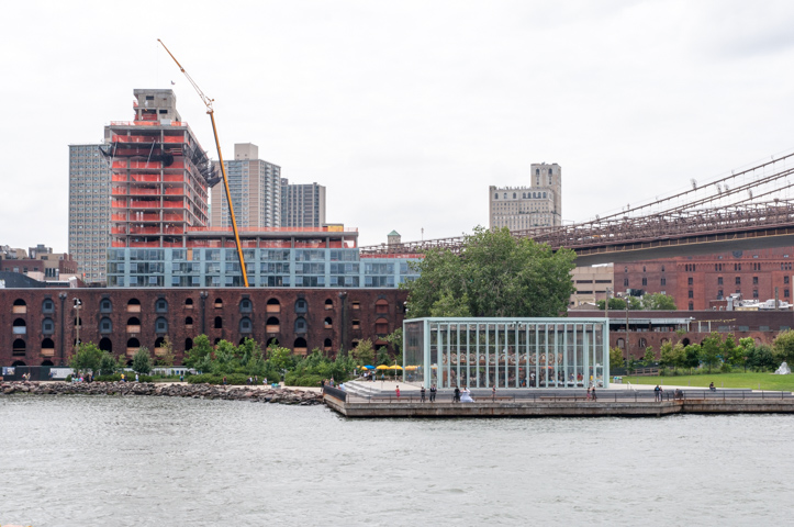
Across the river, in Brooklyn, lies another post-industrial waterfront revitalization project: Brooklyn Bridge Park. Like the South Street Seaport, BBP has converted what was a relic of the East River’s once dominant port into a 1.3-mile, 85-acre park, initially conceived as an idea in 1985, after cargo ship operations in the area closed. The park has been opening in phases since 2010, and is now more than half complete, with the opening of Pier 2 and Pier 4 Beach completed this summer.
Rising steadily along the park’s northern fringe at Pier 1 is Marvel Architect’s Pierhouse, a 108-unit condo and 200-room hotel, which will generate revenue for the park. The hotel portion of the project has reached its full height of ten stories, while the condo buildings that flank the Squibb Park Bridge are just reaching the second floor.
The Pierhouse at Brooklyn Bridge Park.
Directly north of Brooklyn Bridge lies Jane’s Carousel, built in 1922 by the Philadelphia Toboggan Company for Idora Park in Youngstown, Ohio. After that town suffered its own post-industrial decline, the carousel was auctioned off in 1984 to the Walentases, the family of Brooklyn developers that own Two Trees Management. Jane Walentas spent 25 years restoring each of the 48 carved horses and two carriages, and the restored carousel was instated in an enclosure designed by Jean Nouvel at Empire Fulton Ferry, at Brooklyn Bridge Park, in 2011.
Jane’s Carousel (right) and Dock Street Dumbo (left).
Just north of the Williamsburg Bridge lies the Domino Sugar Refinery site, a major waterfront development from Two Trees. SHoP Architects and Field Operations are responsible for the masterplan for the 3.3 million square foot megaproject, with SHoP also designing two towers and curating the architects of the remaining three. No final designs have been unveiled for the towers, but the plan allows for a maximum height of 600 feet. New York will be gaining about 700 affordable units, in addition to 1,600 market-rate apartments, as well as offices, parks, and a range of other facilities.
The iconic refinery will be completely renovated from the inside out, and will be leased as office space targeted to tech and creative tenants. The bin structure with the iconic Domino Sugar sign will be demolished by the end of the summer, but the sign will be saved and installed on the refinery building. Field Operations is overseeing the design of five acres of open space, including salvaging other artifacts of the site’s past industrial uses. There will even be a High Line-esqe element, dubbed the “Artifact Walk” – an elevated catwalk that runs along the refinery and incorporates existing 80-foot-tall gantry cranes. Full demolition of the site should wrap up by year’s end, with infrastructure and groundwork to follow.
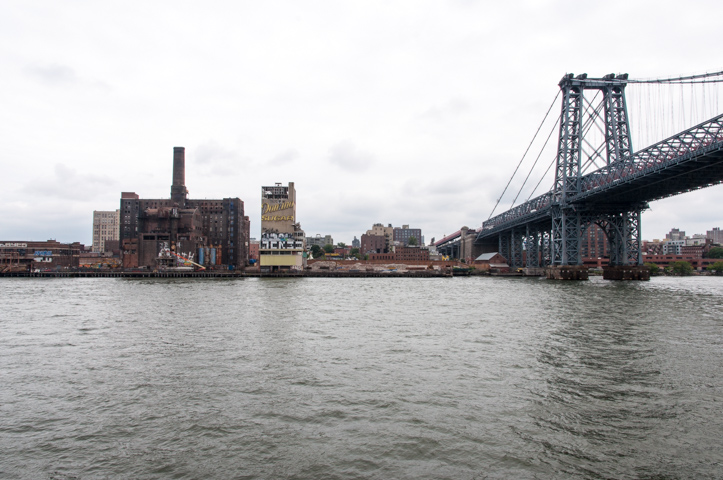
Domino Sugar Refinery.
At the northern edge of Brooklyn’s East River waterfront, an equally impressive scale of development is beginning at Park Tower Group’s Greenpoint Landing. Greenpoint has transformed from farmland, to shipbuilding in the 1800s, to post-industrial decline after the Second World War, and finally to hipster (and increasingly yuppy) enclave today.
On a stretch of land once home to a lumber yard for the shipbuilding industry, Park Tower has plans to build ten towers, several low-rise affordable buildings, waterfront open space designed by Field Operations, and will also provide funding for the construction of Newtown Barge Park. When completed, the entire project will bring 5,500 residential units to the waterfront, including 1,300 affordable units, and a new pre-K through eighth grade school at the corner of Franklin and DuPont Streets. Foundation work has just begun on two low-rise affordable buildings with partner L&M at 21 Commercial Street and 33 Eagle Street.
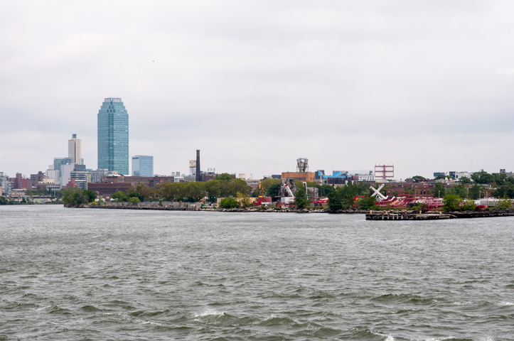
Future site of Greenpoint Landing.
Heading north from Greenpoint towards the southern boundary of Queens, the rapidly rising first phase of Hunters Point South and the towers of Queens West dominate the skyline. SHoP and Ismael Leyva Architects are responsible for HPS’s first phase, a development partnership between Related, Monadnock and Phipps Houses. The development consists of two towers with 925 apartments, all of which will be let at below-market rates. Each tower has a distinct identity provided by its facade: Building A has an orange, black and white color scheme with vertical fins; Building B swaps the orange for blue and emphasizes its windows with protruding frames. Both towers should be ready for move-ins by early 2015.
Phase two, a block south of phase one’s Building B, will bring another set of towers to Hunters Point South. Designed for TF Cornerstone by ODA, with SLCE Architects as the architects of record, the two towers will include 1,193 units, 796 of which will be affordable housing, in a stepped terracing design that provides plenty of outdoor space for tenant activities, including two urban farm terraces. When all phases of Hunters Point South are done, it will be the largest affordable housing development undertaken by the city since Co-op City and Starrett City were built in the early 1970’s.
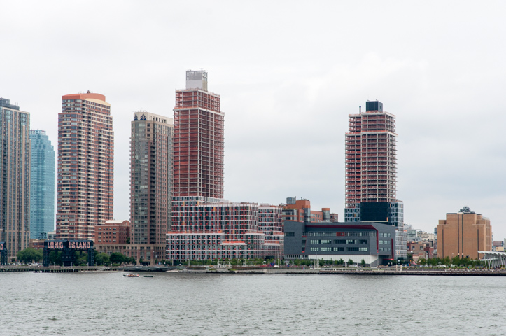
Hunters Point South, Phase One.
There has been much activity in the Tudor City area of Manhattan’s waterfront, beginning with the seven-year renovation plan for the United Nations campus, started in 2008. Most major elements of the campus have seen comprehensive renovations, including the Secretariat Building (2010-2012), the Conference Building (2010-2013) and the General Assembly (2014). Nearby, at 50 UN Plaza, Foster + Partners is wrapping up construction on their 42-story residential tower.
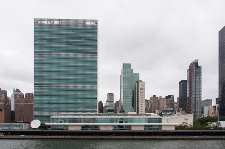
UN Secretariat Building (left) and 50 UN Plaza (right).
Just north of the FDR memorial lies the abandoned south campus of the Goldwater Specialty Hospital, the future home of the Cornell NYC Tech Campus. Conceived in 2011 under the Bloomberg administration as a means of growing the city’s technology sector, Cornell, in partnership with the Technion-Israeli Institute of Technology, beat out proposals from Stanford and Columbia to build a tech-focused campus for 2,000 students on Roosevelt Island, south of the Queensboro Bridge. SOM devised the master plan for the site, and Field Operations has been awarded the landscape design of over 2 acres of open space.
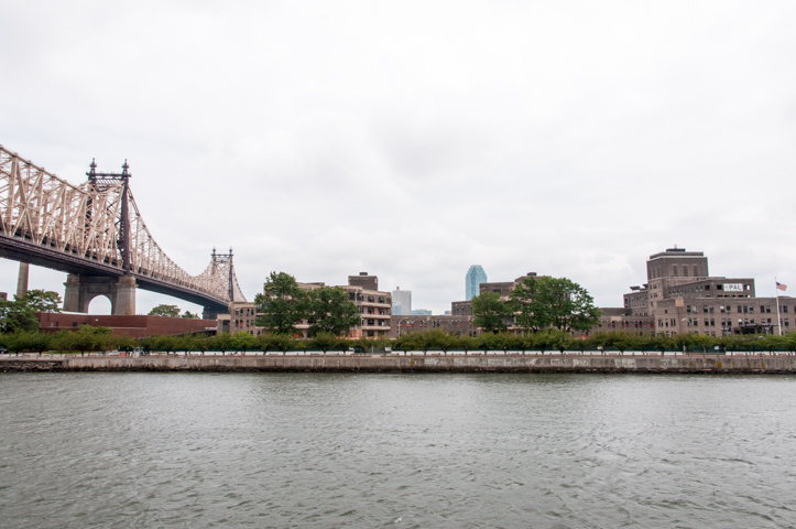
Future site of the Cornell NYC Tech Campus.
The first phase of the campus includes an academic building by Morphosis, a co-location building by Weiss/Manfredi for tech companies to have offices near the school, a residential tower by Handel Architects, an executive education center and hotel that has yet to be designed, and a central utility building. Demolition of the hospital is ongoing, with completion of phase one expected in 2017, and the entire campus two decades later.
Nearby on Roosevelt Island, Related and Hudson Companies’s 480 Main Street, also known as Riverwalk 7, is making significant progress. The 21-story, 200,000-square foot market-rate residential tower was designed by Handel Architects and will be the seventh tower of the Riverwalk development, where construction started in 2000. Work should wrap up sometime in 2015, bringing 266 units to the island.
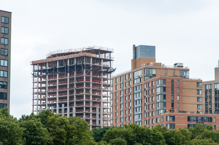
Riverwalk 7.
On the Upper East Side, new developments on the waterfront are mainly from the medical campuses that dominate the area. At East 74th Street, construction has just started on two buildings for the healthcare sector. The 23-story Memorial Sloan Kettering Outpatient Cancer Care building by Perkins Eastman and Ennead will rise 453 feet and allow for outpatient bone marrow transplants, increased use of radiology for cancer treatment, and dedicated space for patients treated in clinical trials.
Meanwhile, the 16-story CUNY/Hunter College Science and Health Professions Building, by the same architects, will rise 346 feet and house the School of Nursing, science research labs, and the physical therapy program. The building replaces earlier facilities from the 1930s and ’50s. Full completion of the 1.15 million square foot development is expected by 2018.

Memorial Sloan Kettering Outpatient Cancer Care Center and CUNY/Hunter College Science and Health Professions Building.
At East 91st Street on Manhattan’s waterfront, the very contentious Marine Transfer Station by Dattner Architects and Greeley and Hansen has recently started construction. The infrastructure project is part of former Mayor Bloomberg’s plan to build four new marine transfer stations spread throughout the city. Historically, waste management facilities have been concentrated in the South Bronx, Brooklyn and Queens.
By spreading out their locations with these four new stations, Bloomberg sought to alleviate some of the perceived inequality in the siting of undesirable waste management facilities. Of course, this plan has not sat well with the Yorkville neighborhood, where the station will be located near NYCHA’s John Haynes Holmes Towers, the Asphalt Green sports complex and Carl Schurz Park.

Future site of Upper East Side Marine Transfer Station.
The tour culminates at North Brother Island, in between the northern boundary of Queens and the South Bronx waterfront. This 20-acre piece of real estate was once home to Riverside Hospital, a facility for quarantinable diseases, which moved from Roosevelt Island in 1885. Its most infamous patient, Typhoid Mary, was quarantined here for over 20 years, until her death in 1938. Since the last facilities shuttered in the 1960s, the island has remained abandoned and closed to all but the birds, for which it is an established sanctuary.
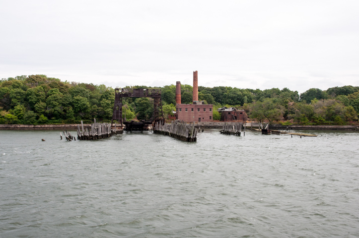
North Brother Island.
New York is on the cusp of realizing plans for the East River that have been in the works for decades. With developments like Hunters Point South, Greenpoint Landing and Domino Sugar, what was once inaccessible land is transforming into waterfront for all New Yorkers to enjoy and some to call home.
Talk about these topics on the YIMBY Forums
For any questions, comments, or feedback, email [email protected]
Subscribe to YIMBY’s daily e-mail
![]()
Follow YIMBYgram for real-time photo updates
Like YIMBY on Facebook
Follow YIMBY’s Twitter for the latest in YIMBYnews